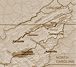
The Holston River flows from Kingsport to Knoxville.
map by Kmusser
Fincastle County, Virginia was created in 1772 from Botetourt County and abolished in 1776. It was divided into Montgomery, Washington and Kentucky Counties.
John McCorkle
John's children probably included:
Joseph McCorkle,
Francis McCorkle
Finley M. McCorkle, and
Martha McCorkle (1768, married
Samuel Scott).
On November 23, 1760, Jacob Everhart sold an enslaved man to John McCorkle and George Smith.
On September 3, 1761, James Brooks sold John McCorkle 127 acres.
The deed of the old church [Piney Creek Presbyterian in Maryland] is dated February 15th, 1771, and was given for a consideration of five shillings, by Abraham Heyter, of Frederick county, province of Maryland, to Patrick Watson, James Galt, and John McCorkle, of the same county and province, and James Barr and James Hunter, of York county, province of Pennsylvania, in trust for a church and burying ground. Mr. [Joseph] Rhea tendered his resignation as pastor of the Piney Creek Church in April, 1776, and, after due deliberation, Presbytery dissolved the pastoral relation. (from Encyclopaedia of the Presbyterian Church in the United States of America edited by Alfred Nevin)
Mrs. Samuel Scott of Jessamine County, Kentucky, tells of the killing of Samuel Cowan ... who, along with her father, John McCorkle, was at Houston’s Fort {Blount County, Tennessee] during this raid. . .She states: Matthew (?) Cowan brought the express (news) from Moore’s Fort to Houston’s Fort that 300 Indians were coming to attack Houston’s Station. The next morning he would start to go back and thought he could get through, but was shot. His horse got in safe (to Castlewood). His wife fainted when she saw the horse - a stud horse, all in a power of sweat. He, (Samuel Cowan) was brought in wounded and died. There my father, John McCorkle, was at the time. There were 300 Indians to 21 families (in the fort). I think the men didn’t exceed thirty. The Indians stayed there about 8 days killing the cattle. They were Cherokees. None of the people in the fort were killed. Relief came in from the Holston and then they left. Samuel Cowan was slain in either June or July, of 1776.(From "Indian Atrocities Along the Clinch, Powell and Holston River," umpublished)
On September 1, 1799, John sold 102 3/4 acres to Henry Spaulding.
On Janaury 25, 1811 John McCorkle was granted 123 acres on the Holston River adjacent to Samuel McCorkle (deceased) and Benjamin Webb
In 1819, John McCorkle was in Washington County, Tennessee.
On January 23, 1823, Joseph, Francis and Finley M. McCorkle, heirs of John McCorkle sold their shares to Samuel McCorkle, Jr.
Carter County, Tennessee was organized from Washington County on April 9, 1796. Elizabethton is the county seat.
Sullivan Co., TN, Deed Book 6, p. 152:
State of Tennessee No. 1932 to John McCorkle
Transcribed by Robert W. Keyes
To all to whom these Presents shall come greeting.
Know ye that in
consideration of an entry made in the office of the Surveyor of the
Sixth District of nunber 349 dated the Thirteenth day of October Eighteen
hundred and and nine [1809] founded on a Warrant of number 149 issued
by Archibald Roane to John Nave for Two hundred acres of land dated
the Sixth day of July Eighteen hundred and eight which said
Warrant is assigned to John McCorkle the enterrer
There is granted
by the said State of Tennessee unto the said John McCorkle and his heirs
a certain tract or parcel of land containing one hundred and
twenty three [123] acres lying in the county of Sullivan in the District of
Washington
begining at two sugar trees on the South bank of Holston
river
Thence along down the same South sixty West two poles to a hickory
and dogwood
then South five West Twenty two poles a long a line of
Samuel McCorkle Deceased to a Poplar
then south Twenty nine West
one hundred and fifty two poles to two white oaks
then north eighty
West Seventy poles to a white oak South six poles to a white oak and
dogwood
then south seventy five West twelve poles to three chesnut
saplings on Benjamin Webbs line
then along the same South
Twenty East one hundred and sixty eight poles to two Chesnut oaks
and a white oak on the on the top of a hill
thence North fifty East
one hundred poles to a forked white oak on Elijah Watsons line
Then north seven East two hundred forty poles to the Beginning
Surveyed December the Fourth 1809
With the herediaments
and appurtenances to have and to hold the said Tract or parcel
of land with its appurtenances to the said John McCorkle
and his heirs forever
In witness whereof Willie Blount governor
of the State of Tennessee hath hereunto set his hand and caused
the great seal of the said state to be affixed to Knoxville
on the twenty fifth day of April in the year of our Lord one
thousand eight hundred and Eleven and of Americas independence
the thirty fifth
By the governor Willie Boount
R Houston Secretary